
Cyclone Murasu Landfall Begins; Heavy Rain, 120 Kmph Winds Lash Andhra Coast, Nearby Areas
Introduction & Key Takeaways
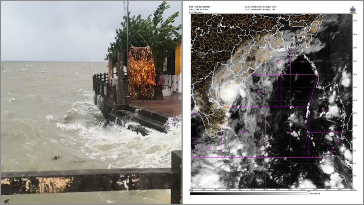
Severe Cyclonic Storm Murasu has officially commenced its landfall process along the Andhra Pradesh coastline, specifically impacting the region near Ongole. As of early November 3, 2026, the storm brought powerful winds and torrential rainfall to the state, prompting significant emergency responses. This event, categorized by the India Meteorological Department (IMD) as a severe weather system, requires immediate attention to public safety and infrastructure resilience. The arrival of Cyclone Murasu underscores the increasing frequency of extreme weather events in the Bay of Bengal, necessitating long term strategic planning for coastal disaster management.
- Landfall began at 01:00 hours IST, with sustained wind speeds reaching 110 kmph and dangerous gusts up to 120 kmph.
- Coastal districts, including Bapatla and Prakasam, remain under a high-alert status due to storm surge warnings of 1.5 meters.
- The storm’s influence extends beyond Andhra Pradesh, causing significant disruptions across North Tamil Nadu and the Union Territory of Puducherry.
- Disaster relief agencies are currently deployed, while local administrations work to mitigate the impact on vulnerable populations.
Background & Context (What Just Happened?)
The development of Cyclone Murasu is part of a broader trend of intense low pressure systems forming in the west-central Bay of Bengal. Meteorological tracking indicated that the system gained significant strength as it approached the south Andhra Pradesh coast. Historically, this region is no stranger to the devastating impact of tropical storms, which have long shaped the socio-economic landscape of the Indian coastline. The timing of this cyclone during the early hours of Tuesday forced local authorities to initiate rapid evacuation procedures and implement school closures across affected zones to minimize casualties.
Root Cause & Deep Dive Analysis (Why Did This Happen?)
Meteorologists point to an unusual warming trend in the surface temperatures of the Bay of Bengal as the primary catalyst for the rapid intensification of such storms. The thermal energy stored within these waters acts as fuel for cyclonic structures, enabling them to reach higher wind velocity thresholds in shorter timeframes. This climatic volatility is not isolated. Much like the recent environmental emergencies across India, the impact of Cyclone Murasu highlights a growing struggle to adapt infrastructure to the unpredictable nature of modern meteorological patterns. The combination of high-speed winds and high tides creates a dangerous storm surge effect, which effectively forces water into low-lying inland areas.
Strategic Implications & Future Impact (What Does This Mean Globally?)
The geopolitical and economic costs of frequent severe weather are significant. Beyond the immediate destruction of homes and agricultural land, such storms severely disrupt local commerce, transportation, and power grids. For Andhra Pradesh, the recurrence of these events necessitates a shift from reactive disaster management to proactive, technology-driven climate adaptation. There is a pressing need for improved early warning systems and hardened coastal infrastructure that can withstand sustained gale-force winds. Furthermore, as similar weather events occur elsewhere, such as the regional unrest often seen after natural disasters, local governments must prioritize the continuity of essential services during and after these crises.
Conclusion & What to Watch Next
As the landfall process continues, the immediate focus remains on search, rescue, and the assessment of damages. The coming days will be critical for recovery, particularly in rural areas where the reliance on agriculture makes them especially susceptible to flood-induced economic loss. Residents in the impacted corridors must remain vigilant and follow directives from the IMD and state disaster response forces until the storm fully dissipates. Moving forward, observers should look for government policy shifts regarding coastal zoning, building codes, and the integration of artificial intelligence in weather forecasting to better anticipate the trajectory of future cyclones.