
Possible tornado in Quebec being investigated after severe storm
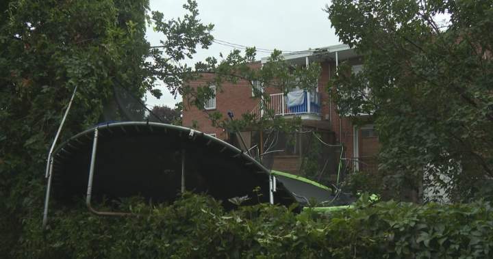
A powerful storm ripped through Repentigny, Quebec, over the weekend, leaving a trail of disarray and sparking an intense investigation into whether a true Quebec tornado may have touched down. Drivers dodged debris and a trampoline was tossed through trees, painting a vivid picture of the chaotic conditions residents faced in the region northeast of Montreal.
As the clean-up begins, the burning question remains: what exactly transpired in the skies above? Environment Canada meteorologist Kate LeClerc noted the presence of “weak rotation” during the event, a phenomenon that doesn’t invariably signal a full-fledged tornado. Yet, the sheer ferocity of the Sunday storm has prompted a dedicated probe.
Was Repentigny Hit by a Quebec Tornado?
The Northern Tornadoes Project, a specialized investigative body based in London, Ontario, working hand-in-glove with Environment Canada, has already deployed teams to the ground. Their mission? To meticulously analyze the damage patterns and determine if a cyclonic system indeed formed and made landfall. Curiously, despite the widespread damage, weather radar during the storm’s peak primarily indicated heavy rainfall, with no strong winds explicitly flagged, meaning no special tornado warning was issued beforehand.
“We did have a severe thunderstorm watch in effect in the morning,” LeClerc explained, “We forecasted a potential, but in the moment we did not forecast that it was going to be that severe.” The actual intensity only became clear in the aftermath. This incident follows a summer marked by severe weather across the province; two confirmed tornadoes, an EF1 in Harrington and an EF0 in Saint-Donat, struck southern Quebec just weeks prior on July 21.
These tempestuous events are not random occurrences. LeClerc attributes the surge in such violent weather to a persistent climatic pattern: “One of the key factors has been hot and humid — those two key elements that have been present on and off this (week) will be another week as well.” Such conditions create a volatile atmosphere ripe for powerful thunderstorms, and the possibility of a Quebec tornado, though rare, increases.
Meanwhile, several southern and eastern areas of Quebec, including the provincial capital region, currently grapple with yellow alert rainfall warnings and severe thunderstorm watches. Residents are cautioned about potential downpours, with some localities bracing for up to 100 millimetres of rain. These alerts explicitly warn of the potential for heavy rain, strong wind gusts, hail, and, critically, an ongoing risk of a Quebec tornado.
For the latest weather information and public alerts across the nation, consult Canada’s official weather information.