US government map of Africa mislabels every country at global conference
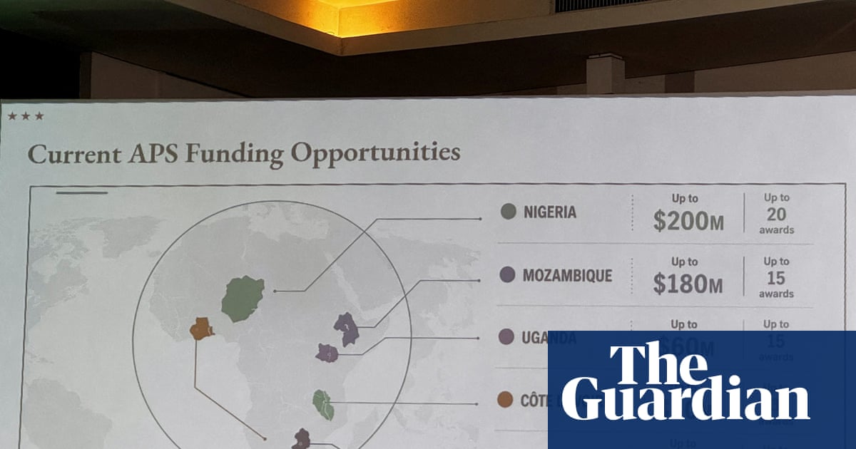
A staggering geographic blunder has rocked a major global conference in Brazil this week: the US State Department displayed an egregiously mislabeled Africa map during a critical presentation. The digital gaffe, which saw entire nations geographically displaced and a landlocked Nigeria materialize in the Sahara, ignited a firestorm of criticism and disbelief among attendees and online.
Screenshots of the bewildering cartographic anomaly quickly proliferated across social media, drawing thousands of views and sharp rebukes. Observers noted the map positioned Mozambique in the Horn of Africa, far from its true southeastern coast, and inexplicably shifted Côte d’Ivoire to the continent’s eastern flank. Such glaring inaccuracies raise serious questions about vetting processes within government agencies.
Behind the Glaring Africa Map Error
A Reuters analysis subsequently revealed an artificial intelligence watermark embedded within the map image itself, suggesting its creation using OpenAI tools. The implications are profound, hinting at a rushed, unverified reliance on technology for critical diplomatic materials. The State Department, in an official statement, promptly accepted full responsibility for the confusion and misrepresentation, attributing the incident to a team member hastily altering a slide deck prior to the event.
Jeff Graham, the top US health envoy overseeing the President’s Emergency Plan for Aids Relief (Pepfar), delivered the presentation at the Aids 2026 conference in Rio de Janeiro. While the State Department maintained discussions remained “substantive and constructive” despite the embarrassing Africa map error, the incident underscored concerns about attention to detail. Matt Petit of the Atlantic Council sharply commented on the widely shared posts: “Whoever created and approved this slide did not know where countries in Africa are and did not care to check their work.” This sentiment resonates with many who expect a higher standard of accuracy from a global power.
The State Department reiterated its commitment to fighting AIDS, even as US funding patterns for initiatives like Pepfar shift. However, the controversy surrounding this significant Africa map error serves as a stark reminder of the vital importance of accuracy and thoroughness in international diplomacy and global relations. For more on the importance of geographical understanding, explore reputable educational resources.